Curriculum
The Geodetic Engineering program is extended over 24 months and is structured into mandatory and compulsory elective modules, including teaching units with a duration of one semester. Each module is completed with an exam. Three different types of modules are offered: lectures, seminars, and projects. The basis of evaluation is credit points (CP).
By the beginning of the first semester, the students are required to choose a major and a minor profile out of the following options:
- Mobile Sensing and Robotics
- Geodetic Earth System Science and Data Analysis
- Spatial Information and Development
The Master's Program consists of five types of courses:
6 General Mandatory Modules, which cover the basic knowledge required for the remaining program.
2 Mandatory Modules of the Major Profile, which was selected in the beginning of the study.
1 Mandatory Module of the Minor Profil, which was selected in the beginning of the study.
5 Compulsary Elective Modules, from which three to five modules have to be from the major profile and up to two from the minor profile
2 Project Module from the Major Profile which introduce to current research topich and train for self-sufficent research.
These topics are meant for preparation towards the Master's Thesis and therefore shoukd be taken from the Major Profile.
1 Master Thesis as written final exam paper in the Major Profile
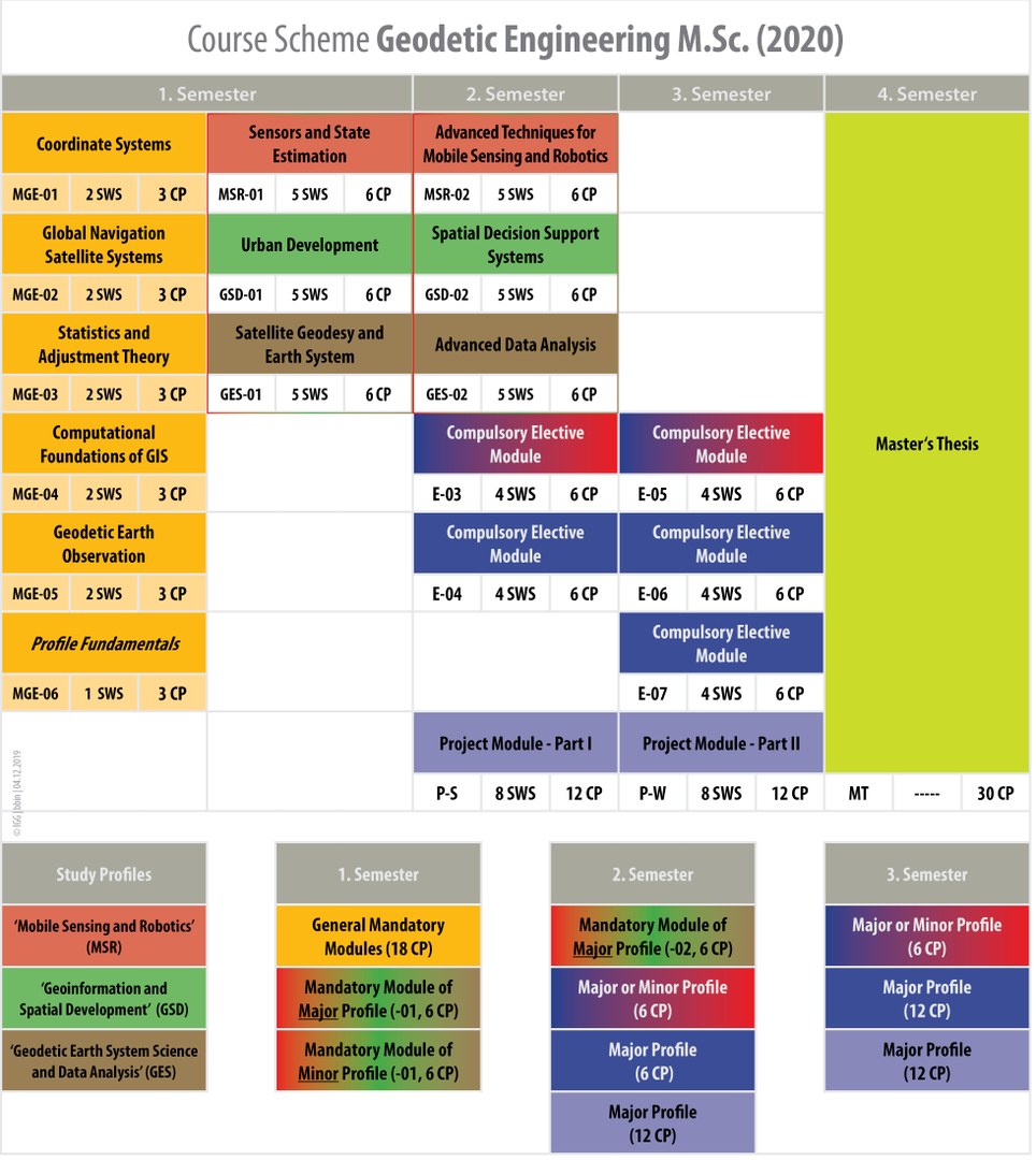
General Mandatory [ 18 CP ]
The modules cover the basic knowledge required for the remaining program. Lectures and exercises cover the following topics: Coordinate Systems, GNSS, Statistics and Adjustment Theory, Geoinformation Systems and Earth Observation. For each student, an individual study will cover topics that were not provided by the student's prior education.
- Coordinate Systems ( MGE-01 | 3 CP )
- Global Navigation Satellite Systems ( MGE-02 | 3 CP )
- Statistics and Adjustment Theory ( MGE-03 | 3 CP )
- Geoinformation Systems ( MGE-04 | 3 CP )
- Geodetic Earth Observations ( MG-05 | 3 CP )
- Profile Fundamentals ( MG-06 | 3 CP )
Mandatory Modules of Major Profile
[ 12 CP ]
In the first semester you will start with a given module of your major profile. This will introduce you to the topics of your major profile.
- Sensors and State Estimation ( MSR-01 | 6 CP )
- Urban Developement ( GSD-01 | 6 CP )
- Satellite Geodesy and Earth System ( GES-01 | 6 CP )
In the second semester you will continue with another given module of your major profile.
- Advanced Techniques for Mobile Sensing and Robotics ( MSR-02 | 6 CP )
- Spatial Decision Support Systems ( GSD-02 | 6 CP )
- Advanced Data Analysis ( GES-02 | 6 CP )
Mandatory Module of Minor Profil
[ 6 CP ]
In the first semester you will start with a given module of your major profile. This will introduce you to the topics of your major profile.
- Sensors and State Estimation ( MSR-01 | 6 CP )
- Urban Developement ( GSD-01 | 6 CP )
- Satellite Geodesy and Earth System ( GES-01 | 6 CP )
Compulsary Elective Modules [ 30 CP ]
In the second and third semester the students choose three to five compulsory modules from their major profile.
From the minor profile students may choose up to two compulsory elective modules or modules of external offers.
- Machine Learning for Robotics and Computer Vision ( MSR-03 | 6 CP )
- Methods for Quality Assurance in GNSS ( MSR-04 | 6 CP )
- Application and Evaluation of Kinematic Mobile-Sensor-Systems ( MSR-05 | 6 CP )
- Techniques for Self-Driving Cars ( MSR-06 | 6 CP )
- Modern C++ for Computer Vision ( MSR-07 | 6 CP )
- Land Management ( GSD-03 | 6 CP )
- Location-Based Services ( GSD-04 | 6 CP )
- Rural Development ( GSD-05 | 6 CP )
- Advanced Algorithms for Geo-Information Systems ( GSD-06 | 6 CP )
- Geo-Information Management in Interdisciplinary Research ( GSD-06 | 6 CP )
- Land Markets and Property Valuation ( GSD-07 | 6 CP )
- Mass Transport Modelling and Monitoring ( GES-03 | 6 CP)
- Numerics in C++ ( GES-04 | 6 CP)
- Monitoring Water and Cryospheric Change from Space ( GES-05 | 6 CP)
- Stochastic Processes ( GES-06 | 6 CP)
- Advanced Methods in Satellite Geodesy ( GES-07 | 6 CP)
(Please note, depending on current research activities, topics of modules may change)
Project Modules [ 24 CP ]
The project modules extend over two semesters and must be chosen from the major profile. Thereby the project modules cover current research topics
- Geodetic Earth System Science an Data Analysis
- Topics: Extension of the existing MATLAB toolbox "Space Geodesy Simulator Bonn" including simulations of measure-ment processes in space-geodetic observing techniques such as SLR, VLBI, GPS, altimetry, and gravity mis-sions; Simulation of perturbing effects, Earth rotation and transformations; Methods of processing satellite data, observing models, simulations of data analysis processes, and planning of new satellite missions or ob-serving stations; Extension of the toolbox’s module handbook
- Qualification goals: Ability to work in a team on a complex and demanding scientific challenge in the field of space geodesy apply-ing contemporary research methods; Capability to document and present the work and results in a concise manner to the scientific community; Understanding scientific literature; Understanding and exploration of in-terdisciplinary contents
- Geoinformation and Spatial Developement
- Topics: Current Topics of geoionformation and spatial developement
- Qualification goals: Successful students are able to work in a group on an open research problem related to geoinformation and spatial development. They are able to define realistic project goals, to choose and apply appropriate methods and tools for accomplishing these goals, and to assess their results critically.
- Mobile Sensing and Robotics
- Topics, e.g.: Moving objects; Trajectory estimation; Simultaneous localization and map-ping; Sensor calibration; Advanced sensor data interpretation; Pointcloud processing; Machine learning for perception; AI techniques for robot navigation
- Qualification goals: Ability to systematically solve relevant problems in the context of mobile sensing and robotics, document the
progress and present results in a scientific way.
Master Thesis [ 30 CP ]
The Master's Program concludes with the Master's Thesis, in which a geodetic problem as to be solved.
Qualification goals: Independent and extensive analysis and interpretation of a research task; Ability to independently cope with a scientific problem in the relevant subject area on the basis of scientific methods within a set period of time; Specialized professional and conceptual skills to assess and present the research results; Systematic search of information and literature; Understanding and using scientific texts; Writing scientific text in a concise way
Ines Barczewski
1.005
Nußallee 17
53115 Bonn
Bernd Binnenbruck
1.004
Nußallee 17
53115 Bonn